George Street North
Fortunately for the comfort of the future city, the rocks on the right hand as Philip entered (that is, the western side of the Cove) did not extend right to the water’s edge. A fairly level ledge of land, averaging perhaps 200ft. wide, ran alongside the water, and it was on this ledge that Governor Philip planted some of his public buildings.
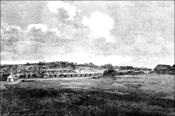
THE FIRST PICTURE OF GEORGE STREET DRAWN ABOUT 1795
The first row of cottages is George street extending from Hunter street (to be seen running up the hill on left) towards King street.
The two behind George street is Pitt Street. At the top of Hunter street on the left the Rev. Richard Johnson’s church is visible
In the illustration below of the sketch plan of the settlement, drawn in July 1788, figures 8 and 9 are upon this ledge. A path was soon worn along this strip, and if you look at Hunter’s sketch you will see this track on the right-hand side of the picture. That path is the George street North of today.
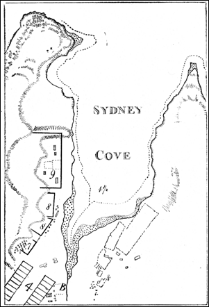
SYDNEY COVE IN JULY, 1788.
Where the figures 8 and 9 appear on the left-hand side was a level strip of land, upon which Governor Phillip planted some of his public buildings. The building just below 9 was the first hospital, which stood in what is now George Street, near Globe street. On the lower 8 the storehouses were built. The figure 4 shows the line of what was to be the principal street, which was to be 200 feet wide. All the Cove from the head near the letter B to the figure 4 1/2 has been filled up, and the end of Pitt Street is now close to that figure.
It needed no bullock waggon to define its course; nature had ordained it within that 200 feet ledge. The somewhat crooked course of George Street North as far as Grosvenor street is simply the result of a man seeking the easiest way in a circumscribed area.
The slight turn from Essex street to Grosvenor street is due to the fact that Phillip’s Lieutenant-Governor selected as the site of his house the south corner of George and Grosvenor Streets, and to the south of it barracks had been erected. At the end of the path in Hunter’s sketch on the right-hand side two buildings may be seen. These were storehouses, which stood in the vicinity of Nock and Kirby’s premises and Essex Street. The path, it will be noticed, turns abruptly to the left at the end.
Today the street turns very slightly. At least as late as 1792 the street cut through the site of Nock and Kirby’s, and, running lower down the slope of the hill than the present roadway, reached Bridge street about midway between the present Pitt and George streets. The reason for this is not hard to discover. Philip had his headquarters on the other side of the Cove.
In October 1788, he employed a gang of convicts to roll timber together to form a bridge over the Tank Stream at the intersection of Pitt and Bridge streets. In travelling from the east to the west side, naturally, the shortest track was taken, and as the traveller had a hill in front of him when he crossed the Tank Stream he turned off as soon as possible to avoid climbing it. It was not until that part of the city south of Grosvenor street had developed into importance and grants had been made that closed the track, that George street, as we know it, became the only road to Bridge street. The reason for the acute turn in the line of George street close to the Sailors’ Institute—i.e., north of Argyle street—is made plain by a glance at the sketch plan of 1788. An escarpment of rock may be seen running almost to the water’s edge. Our forefathers had little time, few implements, and no inclination to quarry a road through this barrier: so they walked around it, and as the land to the north of it fell abruptly to the Cove the track turned sharply to save a descent and a subsequent ascent.
Construction of George Street
The first reference we get in the early annals to the construction of George Street is in Collins’ “Account of New South Wales,” published in 1798, where, under the month of March, 1788, he writes that the principal street of the intended town was marked out at the head of the Cove. This was a noble street 200ft.
wide, which, alas! never materialised. In May of the same year, there is an entry that, “the large storehouse being completed,” a road was made to it from the wharf on the west side.
In April, 1789, Collins writes that the convicts were then employed in forming a convenient road on the west side from the hospital landing-
place to the storehouses. This would be, roughly, from Globe street, opposite the fire station, to Essex street.
George street has rejoiced in four names. At first it was known as Sergeant-major’s Row or Spring Row; then it became High street, a name it retained until 1810, when Macquarie gave the street its present title in honour of his majesty, King George.